GOCE+++ at a glance
 With GOCE having completed
its mission at the end of October 2013, there still exists a wide range of applications that GOCE-derived products can have a
significant contribution to. It has been very recently concluded that GOCE, apart from a high-accuracy static gravity field, can offer unique insights to
oceanographic, engineering and geophysical applications. GOCE offers unique scientific opportunities, especially with the latest R5 GGMs which are still
produced and the low-orbit data during the second phase of its mission. In this respect, the GOCE+++ project tackles the use of GOCE observations for the
generation of end-products that will be useful for the wider scientific community and users.
With GOCE having completed
its mission at the end of October 2013, there still exists a wide range of applications that GOCE-derived products can have a
significant contribution to. It has been very recently concluded that GOCE, apart from a high-accuracy static gravity field, can offer unique insights to
oceanographic, engineering and geophysical applications. GOCE offers unique scientific opportunities, especially with the latest R5 GGMs which are still
produced and the low-orbit data during the second phase of its mission. In this respect, the GOCE+++ project tackles the use of GOCE observations for the
generation of end-products that will be useful for the wider scientific community and users.
The overall objective of the scientific work to be carried out within GOCESeaComp and the newly launched GOCE+++ is to employ
GOCE data products, mainly the derived GGMs and the original SGG data, in order to: model the geoid regionally in the Mediterranean Sea, determine the Mediterranean DOT,
monitor the SLA and use GOCE data for HSU. These should be performed after the validation both in a spectral sense and with external gravity-field related data of the GOCE scientific products.
More specifically, the objectives are summarized as follows:
- Validate all available GOCE, GOCE/GRACE and combined GGMs developed during the GOCE mission based on all employed strategies (DIR, TIM, SPW, GOCO, EIGEN, etc.).
- Determine the spectral behavior in terms of signal and error PSD functions of the GOCE GGMs and assess their accuracy with external GPS/Leveling and free-air gravity anomaly data sets.
- Use the GOCE-derived GGMs to model the time-variable DOT in combination with satellite altimetry data.
- Determine empirical and analytical covariance functions for the SLA and DOT.
- Model the Earth’s gravity field in terms of geoid model development, with high-accuracy, for the wider Greek territory with the use of GOCE data.
- Model the DOT in the Mediterranean region with the use of GOCE data.
- Determine the systematic offsets of the Greek LVD.
- Estimate, with the use of GOCE data, an optimal zero level geopotential value for mainland of Greece, provide its connection/offset to a WHS and unify the several LVDs of the islands with respect to the mainland using a GOCE geoid.
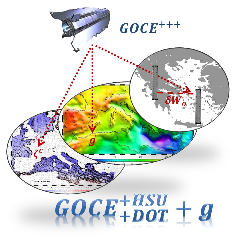
In this respect, the GOCE+++ project tackles the use of GOCE observations for the generation of end-products that will be useful for the wider scientific community and users. HSU over Greece is an issue of major importance since neither the mainland nor the islands use a common zero level geopotential value and/or common referend. HSU can be performed with GOCE so that a unified vertical reference datum can be generated for Greece. DOT plays a crucial role in both geodetic and oceanographic applications, since it provides the necessary information to transform altimetric observations to geoid heights and vice versa. Moreover, the resulting circulation models give the opportunity for environmental and coastal processes monitoring. DOT determination can be benefited greatly from GOCE, since the latter maps with high-accuracy the medium band of the geoid spectrum where the DOT is focused. Finally, the refinement of the regional geoid for the wider Hellenic region is a key issue, taking into account that the current national geoid dates back to the late ‘80s and is obsolete. Moreover, a combined GOCE-based and local gravity anomaly geoid can serve as the reference surface for engineering applications as well as for environmental monitoring. GOCE SGG data can fill the gap in the existing local gravity databases, especially over mountainous terrain where in-situ observations are scarce or non-existent.
The aforementioned set the broad picture of the proposed GOCE+++ project, following as a natural continuation of the successful GOCESeaComp project. The main goal is to use GOCE data, either in the form of SGG observations and GGMs, in order to
- achieve the unification of the Hellenic vertical system,
- determine improved representations of the DOT and circulation in the Mediterranean and
- estimate a regionally improved geoid model for the wider Greek area based on GOCE observations and local free-air gravity anomalies.